Lhotse - Nepal
History
An early attempt on Lhotse was by the 1955 International Himalayan Expedition, headed by Norman Dyhrenfurth. It also included two Austrians (cartographer Erwin Schneider and Ernst Senn) and two Swiss (Bruno Spirig and Arthur Spöhel). They were accompanied by 200 local porters and several climbing Sherpas. After a brief look at the dangerous southern approaches of Lhotse Shar, they turned their attention, during September and October, to the Western Cwm and the northwest face of Lhotse, on which they achieved an altitude of about 8,100 metres. They were beaten back by unexpectedly strong wind and cold temperatures. Under Schneider's direction they completed the first map of the Everest area. The expedition also made several short films covering local cultural topics, and made a number of first ascents of smaller peaks in the Khumbu region.
The main summit of Lhotse was first climbed on May 18, 1956 by the Swiss team of Ernst Reiss and Fritz Luchsinger from the Swiss Mount Everest/Lhotse Expedition. On May 12, 1970, Sepp Mayerland and Rolf Walter of Austria made the first ascent of Lhotse Shar. Lhotse Middle remained, for a long time, the highest unclimbed named point on Earth; on May 23, 2001, its first ascent was made by Eugeny Vinogradsky, Sergei Timofeev, Alexei Bolotov and Petr Kuznetsov of a Russian expedition.
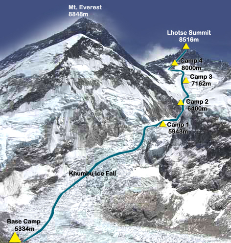
The Lhotse standard climbing route follows the same path as Everest's South Colroute up to the Yellow Band beyond Camp 3. After the Yellow Band the routes diverge with climbers bound for Everest taking a left over the Geneva Spur up to the South Col, while Lhotse climbers take a right further up the Lhotse face. The last part to the summit leads through the narrow "Reiss couloir" until the Lhotse main peak is reached.
As of December 2008, 371 climbers have summitted Lhotse.
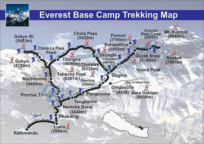
Lhotse Trekking Map
Lhotse Itinerary
Arriving in Kathmandu:
1) Arrive Kathmandu (1300 meters)
2) Orientation day in Kathmandu
Trekking to Basecamp:
3) Fly to Lukla (2,860 metres). Walk to Phakding (2650 metres).
4) Walk to Namche Bazaar (3450 metres).
5) Rest and acclimatization in Namche.
6) Walk to Pangboche (3750 metres).
7) Walk to Pheriche (4250 metres).
8) Walk to Dugla (4600 metres).
9) Walk to Lobuche (4900 metres).
10) Walk to basecamp (5300 metres).
11) Rest, organization, and training day in basecamp.
12) Rest, organization, and training day in basecamp.
13) Rest, organization, and training day in basecamp.
Acclimatization:
14) Walk to Pumori basecamp.
15) Walk to Pumori ABC, return to basecamp;
16) Rest in basecamp;
17) Acclimatization trek to the top of Kala Pattar (5500 metres), return to basecamp
18) Rest in basecamp.
19) Climb to camp 1 (5800 metres)
20) Walk to camp 2 (6200 metres) return to camp 1,
21) Rest in camp 1.
22) Rest in basecamp.
23) Rest in basecamp.
24) Walk to camp 1.
25) Walk to camp 2.
26) Rest in camp 2.
27) Explore route to camp 3 (7300 metres) return to camp 2.
28) Return to basecamp.
29) Rest in basecamp.
30) Rest in basecamp.
31) Rest in basecamp.
32) Walk to camp 1.
33) Walk to camp 2.
34) Rest in camp 2.
35) Walk to camp 3.
36) Descend to camp 1 or camp 2.
Rest in Basecamp or in a Lower Village:
37) Return to basecamp.
38) Rest in basecamp or descend to a lower village such as Pangboche;
39) Rest in basecamp or a lower village.
40) Return to basecamp from lower village.
41) Rest in Basecamp
Summit Days: SUMMIT SOMEWHERE IN THIS WEEK
42) Climb to Camp 1.
43) Climb to Camp 2.
44) Climb to Camp 3.
45) Climb to Camp 4.
46) SUMMIT
47) SUMMIT
48) SUMMIT
Going Home:
49) Return to camp 2.
50) Return to basecamp.
51) Pack up basecamp.
52) Trek down to Pheriche.
53) Trek down to Pangboche.
54) Trek to Namche.
55) Trek to Lukla.
56) Flight to Kathmandu.
57) Flight Home.
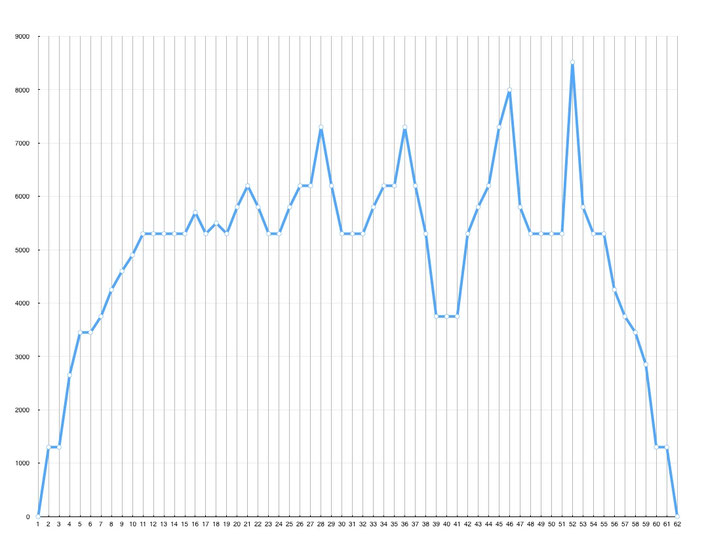
Route Profile Lhotse trek and climb
Lhotse Climbing Route